


High water expected to linger
By Jake Davies - West Carleton Online
(Editor’s note: As we did during the 2017 flood, 2018 tornado, 2019 flood and COVID-19 pandemic, we are making our coverage of potential extreme flooding in 2023 free access to our entire community providing flooding updates, on-site coverage, important information and resources to West Carleton and beyond, so those outside the area can better understand what is happing in our rural community)
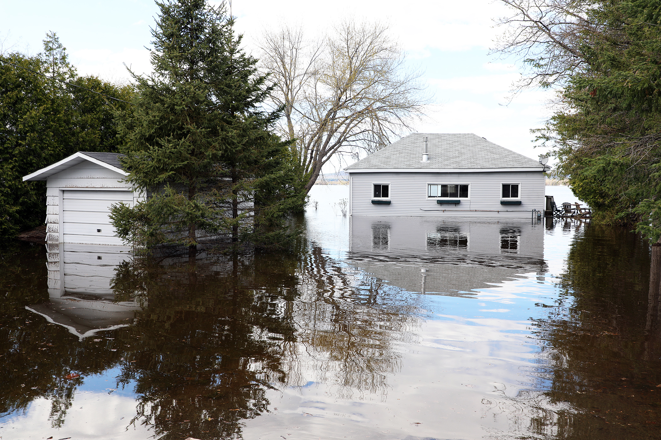
WEST CARLETON – The Ottawa River flooding currently waterlogging dozens of homes along West Carleton’s riverside communities is slowly declining this week, but expected to linger for some time yet.
The 2023 freshet peaked sometime over the weekend, while many homeowners, city staff and volunteers continued to fill, deliver and install sandbags.
On Saturday, the Ottawa River in the Constance Bay area measured 59.39 metres above sea level. The April 21 peak was 60 m.
The West Carleton Disaster Relief (WCDR) website, using data from the Ottawa River Regulation Planning Board (ORRPB), no longer has a measurement available for Constance Bay. Instead, data from Chats Lake at Arnprior says the river was expected to drop 10 centimetres since yesterday (May 9) and is expected to drop another 20 cm over the next two days.
The level at Lake Deschenes at Britannia also reported a 10-cm drop over yesterday (60.5 m May 10), and a further 20 cm drop to 59.85 m by Friday (May 12).
The Mississippi Valley Conservation Authority (MVCA) expects the high water to stick around though after peaking May 5 and May 6.
“Water levels along the main stem of the Ottawa River reached peak levels on May 5 and 6 due to above normal snow melt in the upper region of the basin this spring, combined with large regional rain events that occurred over several days in late April and early May,” MVCA water resources technologist Jennifer North released in a statement today (May 10).
“Based on Ottawa River Regulating Committee forecasts, it is expected water levels will continue to slowly decline along the main stem of the Ottawa River,” North said. “Water levels are expected to remain high for the next few weeks.”
Affected locations include flood-prone areas at Chats Lake, Constance Bay area, Britannia/Lac Deschênes, Cumberland, City of Clarence-Rockland, Township of Alfred Plantagenet, and other vulnerable areas down to Carillion Dam.
Meanwhile, yesterday (May 9) the MVCA also stated the Flood Warning for the Mississippi and Carp River watersheds will remain in effect for the next week at least.
“Levels and flows continue to decline slowly in all locations along the main stem of the Ottawa River,” the ORRPB released in a statement yesterday (May 9). “With the forecast of sunny weather and little precipitation, levels are expected to continue declining over the coming week. For the river reach between Gatineau (Hull Marina) and the Grenville-Hawkesbury area, levels are expected to decline between 30 and 45 cm over the next four days.”
While the height of the river has the biggest effect on flooding in West Carleton, groundwater does its fair share of damage as well, especially in Constance Bay.
Many further inland homes are surrounded by water due to the rising ground water, that no longer has a place to go, due to the saturation of the sand-based ground. In 2019, West Carleton Online reported on homeowners whose basements cracked due to the pumping going on inside their homes and the water pressure built up outside their home due to the saturated water.
Many riverside homes in the community no longer have the option of pumping, their electricity and gas cut due to the risk to the utilities from the floodwater.
Ward 5 Coun. Clarke Kelly says many homes are still dealing with the fast-rising water from Friday (May 7).
“Constance Bay is made up of a lot of sand, so water does seep through it very quickly,” Kelly said in a recent television interview. “When the river rises, the water table rises with it and there’s just no where for the water to go.”
Kelly says roughly 80 homes in Constance Bay are being impacted by flooding in one way or another.
“It can be a little deceiving when you drive down Bayview Drive because you look on the water side and see that the water is receding,” Kelly said. “But also on the other side of the road we have people dealing with a lot of ground water coming up into their basement.”
Levels in West Carleton are similar to those faced in 2017 (60.44 m peak). Kelly says while waters are receding, it is taking place slowly.
“It is frustrating, and it could be several weeks with people in this situation,” he said.
Ottawa’s Public Safety Service director Beth Gooding also updated council today (May 10), on the city’s flood response.
“The city’s Emergency Operations Centre (EOC) is still asking residents to remain vigilant, to keep their protective measures (e.g., sandbags) in place for now, and to monitor conditions closely,” Gooding wrote in a memo to council obtained by West Carleton Online. “Over the course of the past few days, the EOC has continued to work with community partners to ensure that the right supports are in place for impacted residents.”
This information is being regularly updated on the city’s website (ottawa.ca/springflooding).
“The EOC also worked with Sauvetage Bénévole Outaouais – Ottawa Volunteer Search and Rescue (SBO-OVSAR) on a targeted, two-day deployment for specific supports related to sandbag reinforcement and site assessments in the Constance Bay area,” Gooding said.
To see a short video of some of their work, click here.
“We anticipate that if conditions hold, we will be able to start transitioning to flood recovery,” Gooding said.
This will include:
- Debris management (including guidance on the safe disposal of sandbags);
- Community supports related to well water testing and information on septic systems, among other topics; and,
- Roadway and water infrastructure inspections and rehabilitation.
“It’s been heartwarming to see community members working together to support each other,” Gooding said. “We know, however, that this is a very stressful time. For mental health-related resources and supports, we are encouraging residents to visit the Ottawa Public Health Mental Health site.”
Before the water crested this past weekend, we unfortunately saw some additional impacts in flood-prone areas. We now assess that approximately 160 properties have implemented protective measures (e.g., sandbags). In addition, we estimate there are a total of 80 properties with septic systems or private wells that have been compromised by flooding. There are currently 17 properties experiencing utility disruptions due to flooding.
WCDR continues to assist those affected by the flood and continues to recruit volunteers to help those in need.
On the WCDR website, you can find contact information, volunteer sign-up forms, an interactive map of sandbag locations (and road closures), water levels and much more.
To see all West Carleton Online’s coverage of the 2023 freshet, click here.


