


MVCA flood meet shares, gathers info
PAKENHAM – The Mississippi Valley Conservation Authority (MVCA) hosted two lightly attended information sessions related to updated floodplain mapping for the lower Mississippi River including flows through West Carleton last week.
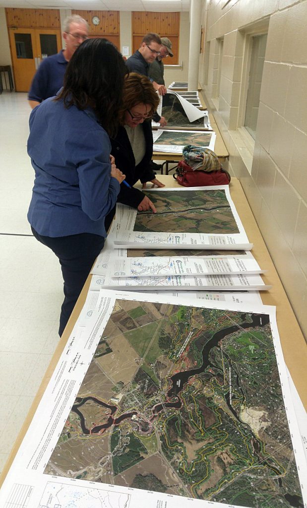
The MVCA hosted a session in Carleton Place on Tuesday, Dec. 3, and a session in Pakenham at the Stewart Community Centre Wednesday, Dec. 4. West Carleton Online attended the Pakenham meeting where we spoke with MVCA environmental planner Diane Reid and MVCA water resources engineer John Price.
“Not a huge turnout last night,” Reid said of the Carleton Place session. “Not as many as we would have liked.”
The MVCA recently updated its floodplain mapping for the Mississippi River, downstream of the Hwy. 7 bridge in Carleton Place to the Ottawa River. The Mississippi River enters West Carleton at the western edge near Pakenham flowing north-east under Hwy. 417 and heading to the Ottawa River through Galetta.
“It is all this reach that we are here to talk about tonight,” Price said. “We do have flood mapping for all this area, but it was done in 1983. So, obviously it’s quite old. So, it’s an update from the standpoint that we already have floodplain mapping, but the analysis is all new.”
Much of the monitoring of this section of river comes from a stream gauge in Appleton.
“There’s a stream gauge in Appleton that has 101 years of data now, so the flow for the Mississippi is based on a frequency analysis of that, the recorded flows of that gauge,” Price said. “And then you pro-rate it for different areas down the stream.”
That’s not the only information used for floodplain mapping though.
“The three main steps are calculating the flow based on those flows, calculating the water levels, and then based on those water levels, delineating the lines,” Price said. “So, the topographic information is all new. As you may know, the City of Ottawa on an ongoing basis does Light Detection and Ranging (LIDAR – a remote sensing method that uses light in the form of a pulsed laser to measure ranges to the earth). So, we tacked on to one of their projects a few years ago, to get the topographic information for this area, so that’s all new. And that goes in to the hydraulic model and is also used as a base to draw the lines, so everything is tied together.”
All that new technology, not readily available in 1983, tells the MVCA not much has changed in the Galetta section of the Mississippi River.
So, generally the flood line for all this area hasn’t changed to a great extent,” Price said. “The geographic extent hasn’t changed any in a great degree since the original mapping was done. So, the Galetta area is much the same. From a regulatory flood standpoint, we have a tributary going in to a much larger river, the Ottawa River. The causes of the flood event on the Ottawa River, because it’s such a massive drainage area in to the Mississippi, the same snow and rainfall event, isn’t going to coincide. From a regulatory standpoint, the downstream end, when you have a tributary going in to a larger river, the greater of the 100-year-backwater from the Ottawa in this case, as opposed to the 100 year flow, the greater of those two elevations is the regulatory flood event. From this section just downstream of Galetta downstream to the Ottawa River is actually the backwater from the Ottawa River, the 100-year backwater which is the regulatory flood event.”
But the floodplain is not exactly the same.
“Basically, one of the changes we noticed, is this little island (Galetta Island, south of the village centre on Mohr’s Road),” Price said. “You can see from the topography we have it is actually pretty flat. The old mapping, and there’s these two areas, is they are kind of islands above the flood mapping, the old mapping had allotted this, a lot more of this area out of the flood plain, but now, you can see there are only two areas above the flood plain.”
This floodplain revision is one of the bigger jobs for the MVCA.
“It’s a much more complicated system then when you were at Harwood Creek, partly because of what I previously mentioned, partly because you have dams here and upstream as well,” Price said. “It is a much more complicated study than a smaller watercourse.”
The evening was also a time for the MVCA to collection information as well. The new mapping doesn’t go to the board for adoption until March.
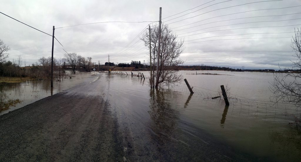
And for once, West Carleton Online provided information rather than just recording information. The draft floodplain mapping shows Mohr’s Road over Galetta Island is above the 100-year-flood designation. West Carleton Online could confirm the road was flooded the week of April 21, 2019. City of Ottawa staff had to close the road due to the damage caused and the danger of it being underwater.
“Okay, we’re going to want to note that,” Price said. “This is part of the reason we have these sessions, to gain local knowledge. There may have been some other reasons the road flooded. We will have to look in to why it happened. To be conservative we don’t assume anything is going through the station, the logs are out and the gates open.”
Price said all dams along the map’s area are run-of-the-river, and things like prognostications such as potential climate change are not taken in to consideration.
“We’re not seeing anything substantial,” Price said. “People are talking about climate change. Whatever trends are in that 101 years of data we assume are going to continue in to the future. There’s no way to include climate change because the data doesn’t exist.”
Price said the MVCA would need direction from the province to consider other options like climate change.
Price says other areas in the province may not have to use the calculations the MVCA does for the Mississippi area because other areas have experienced a 100-year-flood. Last year’s flooding of the Mississippi River did not reach 100-year-flood levels. Places like Toronto that experienced Hurricane Hazel in 1954 and The Timmins Storm in 1961 have.
“Most other provinces have a return period,” Price said. “Actual storms that occurred that were greater than a 100-year-flood. Last year’s flood data is in there and included in the frequency analysis.”
Last spring did not reach that level but “it was close.”
“In 1998 the Appleton gauge had a flow measurement of 282 cubic-metres per second after a large thunderstorm,” Price said. “This year it was in the 267 range. So, it was close.”
MVCA staff expect to have the new maps in front of the MVCA board by March.
“That’s staff’s intent,” Price said. “What I can say confidently is it won’t go to the board until at least March.”
Price says staff will continue to take input up to that time period.
To see the floodplain map for the Galetta area, click here.
For all the maps along the updated section, click here and scroll to the bottom of the page.


Have the new flood maps been approved? If yes where can we see them?
Try this link: https://ottawa.ca/en/city-hall/get-know-your-city/maps-ottawa#how-find-out-if-your-house-1-100-year-flood-plain