Ottawa River expected to peak Friday
By Jake Davies - West Carleton Online
(Editor’s note: As we did during the 2017 flood, 2018 tornado, 2019 flood and COVID-19 pandemic, we are making our coverage of potential extreme flooding in 2023 free access to our entire community providing flooding updates, on-site coverage, important information and resources to West Carleton and beyond, so those outside the area can better understand what is happing in our rural community)
WEST CARLETON – Between Saturday, April 29 and yesterday (May 2), 63.1 millimetres of rain has fallen on Ottawa, and it continues to pour today (May 3). All that rain, is making its way to the Ottawa River.
That rain has affected water levels, not just along the Ottawa River, but across eastern Ontario, but Ottawa River neighbours, especially though West Carleton, are taking the brunt of the flooding so far.
“Heavy rain in recent days across the Lake Ontario-St. Lawrence River basin has led to rapid increases in Ottawa River flows and rising Lake Ontario water levels,” the International Lake Ontario-St. Lawrence River Board (ILOSLRB) released in a statement yesterday (May 2) evening.
For those who battled 2019 extreme flooding in 2019, they are all too familiar with the ILOSLRB and the International Joint Commission (IJC). The IJC is a bi-national organization established by the governments of the United States and Canada under the Boundary Waters Treaty of 1909. Its responsibilities were expanded with the signing of the Great Lakes Water Quality Agreement of 1972.
The IJC has two main responsibilities including approving projects that affect water levels and flows across the boundary and investigating transboundary issues and recommending solutions. The IJC’s recommendations and decisions take into account the needs of a wide range of water uses, including drinking water, commercial shipping, hydroelectric power generation, agriculture, ecosystem health, industry, fishing, recreational boating and shoreline property.
Many in 2019 felt the IJC keeping water levels along the St. Lawrence Seaway high enough to allow its use for shipping was a big part of the troubles faced by West Carleton residents in the spring of 2019.
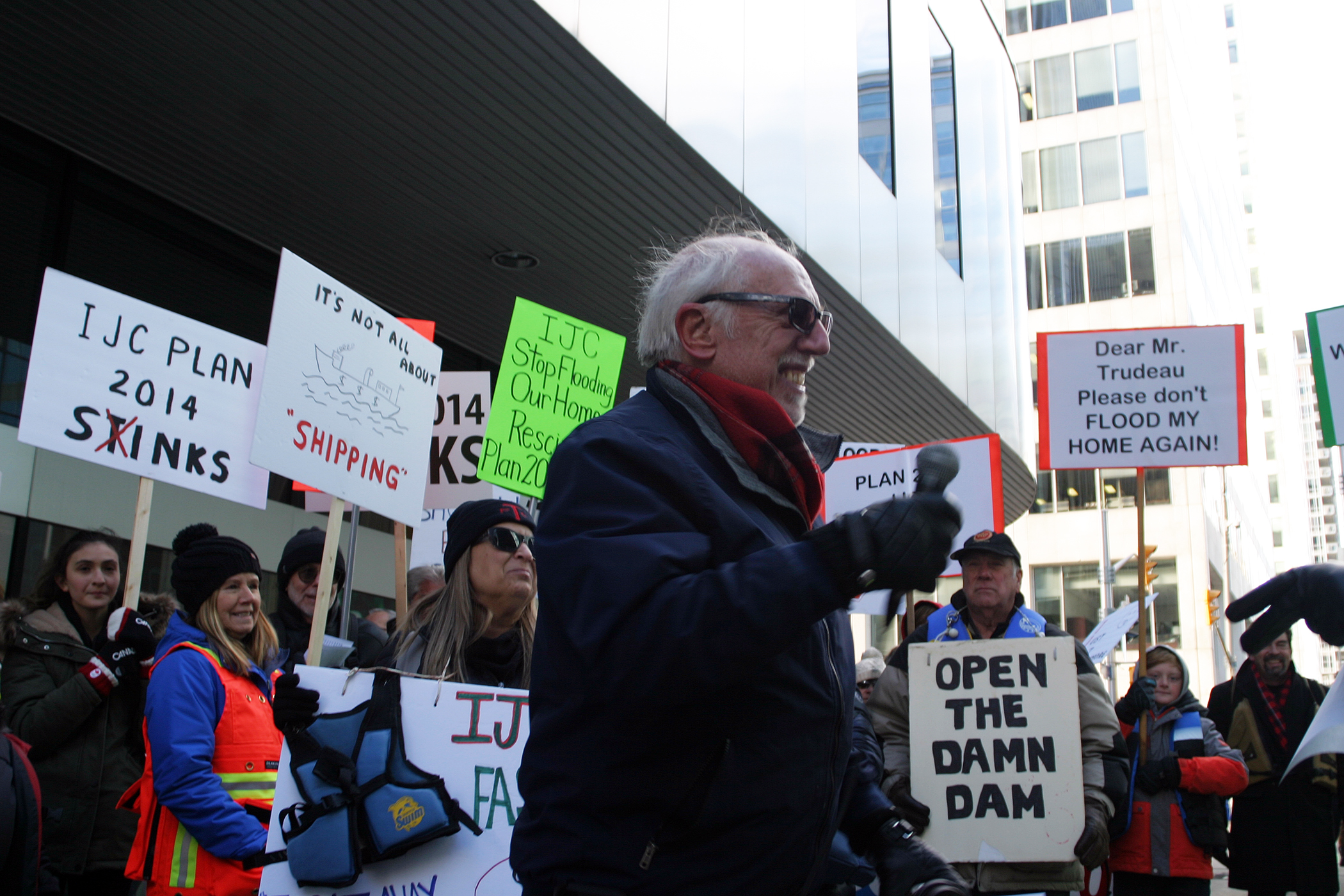
In the fall directly following 2019 extreme flooding, many West Carleton residents joined a group of roughly 200 protestors from across eastern Ontario to protest Plan 2014 outside of IJC’s Ottawa offices.
“Basically, my concern is over what’s going to happen with our house next year,” Constance Bay’s Bruce McClure told West Carleton Online at the 2019 protest. “The water level last year was two-and-a-half feet above our basement floor. We were fortunate, we were able to keep the water out. If the water was any higher there isn’t much we could have done.”
Then councillor Eli El-Chantiry was also at that protest.
“I’m trying to bring some attention to what we’ve been asking for all along, an independent review,” El-Chantiry told West Carleton Online. “What took place and where we go from here. I’m just saying if this is climate change, then fine, what’s your plan to deal with climate change? Are you going to buy some people out? Are you going to help them to relocate? Are you going to give them money to protect their property and build higher? So far, we haven’t heard anything other than you can apply for Ontario’s disaster relief and hopefully you will qualify, but there’s no plan for the future. We were hoping all along to open that dialogue and have a review, I’m not pointing the finger at anyone, maybe there’s no one to point the finger at. We need to know what we need to be prepared for and protect our residents.”
Fast forward to the 2023 freshet, and not many of El-Chantiry’s questions were answered, but the West Carleton community is firmly entrenched in another bout with spring flooding.
According to the ILOSLRB, Lake Ontario levels have been rising at a rate of approximately two centimetres per day and are expected to reach 75.30 metres (247.05 feet) today (May 2) while levels of the St. Lawrence River at Pointe-Claire (Montreal) have risen above 22.20 m (72.83 ft).
“Continued wet weather and runoff from the recent rains may result in flooding of vulnerable areas along the Lake Ontario shoreline as well as downstream along the St. Lawrence River, including Lake St. Louis and Lake St. Pierre,” the OLOSLRB said. “At this time, the water levels of Lake Ontario and St. Lawrence River are expected to remain below the record-highs observed in 2017 and 2019. The ILOSLRB is monitoring the situation. The Lake Ontario outflow into the St. Lawrence River continues to be adjusted in accordance with the Plan 2014 F limit.”
Ontario Power Generation adjusted the gates at the Iroquois Dam this morning (May 2) to prevent extremely high levels on Lake St. Lawrence. Lake St. Lawrence is the portion of the St. Lawrence River upstream from the Moses-Saunders dam to Iroquois, ON. This action does not change the outflow from Lake Ontario nor water levels elsewhere on the system.
Closer to home, the Mississippi Valley Conservation Authority (MVCA) has re-instituted a flood warning for Dalhousie Lake and the Clyde River, which eventually feed in to the Ottawa River. The MVCA terminated the past flood warning on April 26 after declaring one on those same water systems about 16 days earlier.
Now the MVCA is warning residents again about the high water.
“The MVCA has upgraded its Flood Watch to a Flood Warning for Dalhousie Lake and Clyde River and has included Mazinaw Lake/Little Marble and Marble Lakes,” MVCA water resources technologist Jennifer North released in a statement this morning (May 3). “With more rain in today’s forecast than anticipated, flows and water levels continue to increase causing flood conditions throughout the watershed.”
Mazinaw Lake/Little Marble and Marble Lakes – water levels have increased rapidly over the last 48 hours. Outflows from Mazinaw Lake have increased sharply and flooding is expected on Little Marble and Marble Lakes.
Dalhousie Lake – water levels are expected to increase over the next 24 hours with the ongoing rain. Water levels are expected to increase by 10 to 15 cm from current conditions of 157.40 m.
Clyde River – flows are expected to increase with the rain today and will remain high for the next few days.
“Residents in flood prone or low-lying areas historically susceptible to flooding should take the necessary precautions to protect their property,” North said. “Parents are encouraged to remind their children about hypothermia and the dangers of playing near fast flowing water.”
The MVCA Watershed Conditions Statement is in effect until the end of the day on Monday, May 8, and will be updated at that time unless the forecasts change.
The Ottawa River Regulation Planning Board (ORRPB) predicts the upper Ottawa River will peak on Thursday (May 4), and the lower Ottawa River, through West Carleton, will peak Thursday or Friday (May 5).
“Flows and levels on the Ottawa River continue to rise due to increased runoff from significant rainfall over the entire basin received over the last few days,” the ORRPB released in a statement yesterday (May 2) evening just before 6 p.m. “Levels are expected to peak in all locations on Wednesday or Thursday from Mattawa down to Chats Lake, and on Thursday or Friday from Lake Deschenes down to the Hawkesbury/Grenville area. Levels should remain 40 cm to 70 cm below the historical levels of 2019 depending on locations.”
Levels in Mattawa and Pembroke are now expected to slightly exceed the major flood threshold.
“Levels are above major flood threshold in Lake Coulonge since April 19 and are expected to exceed that threshold in Chats Lake and Lake Deschenes today (May 3),” the ORRPB said. “Between Ottawa/Gatineau and the Hawkesbury/Grenville area, levels are expected to exceed the major flooding thresholds starting today in flood prone areas. The major flood threshold is defined as the level at which one or several streets are beginning to flood, with several houses/buildings or neighbourhoods being affected.”
Because of that, West Carleton Disaster Relief (WCDR) is calling for volunteers as residents continue the back-breaking work of flood prep.
“More homes are threatened as the water levels have risen above last week’s peak,” the WCDR released in a statement today (May 3). “Volunteers to help fill sandbags are needed today and the coming days. To volunteer call us at 613-447-4446 or click https://bit.ly/WCDRvolunteer. Please help your neighbours.”
Ward 5 Coun. Clarke Kelly, who has been on the ground every day of the flood season so far, shares a bit of information on where those volunteers are needed.
“As water levels continue to rise, here are some specific locations where volunteers are required,” Kelly released in a statement today (May 2). “We need help filling bags in Constance Bay and we need people with trucks and trailers to deliver sandbags, particularly in Dunrobin at the corner of Greenland and Armitage.”
For more information from the IJC see the below links:
Lake Ontario Outflow Changes: https://ijc.org/en/loslrb/watershed/outflow-changes
Plan 2014 F limit: https://ijc.org/en/loslrb/watershed/faq/4#4-8-2
Ottawa River Outflows: https://ottawariver.ca/