Ottawa River expected to rise 30 cm
By Jake Davies - West Carleton Online
(Editor’s note: As we did during the 2017 flood, 2018 tornado, 2019 flood and COVID-19 pandemic, we are making our coverage of potential extreme flooding in 2023 free access to our entire community providing flooding updates, on-site coverage, important information and resources to West Carleton and beyond, so those outside the area can better understand what is happing in our rural community)
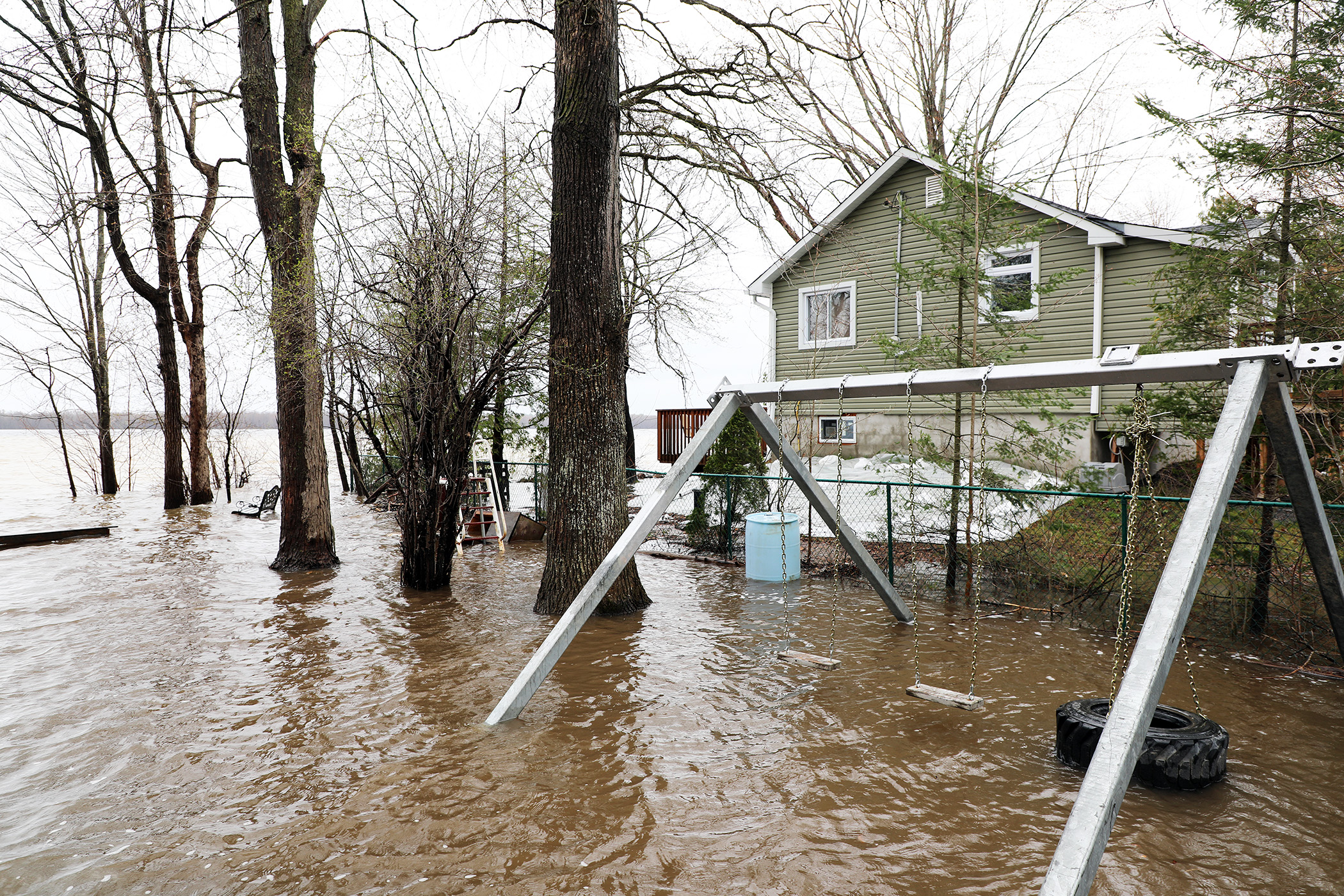
WEST CARLETON – Days of rainfall have had an expected effect on river levels and flows throughout West Carleton, as residents brace for what will be the expected second peak in the 2023 freshet.
Way back on April 18 as the West Carleton riverside community was preparing for the just-called flood warning and West Carleton Disaster Relief’s (WCDR) flood response director Heather Lucente, just hours in to this year’s flood response, was already thinking about the second peak.
“We still have all that northern water to come down,” Lucente told West Carleton Online from the just established WCDR command centre at the Constance Bay community centre. “Usually, we get that first little peak, and then we get that secondary, higher peak when the northern water comes down. We’re going to be developing our teams and are systems to be able to accommodate getting enough volunteers to get out and protect property, so we can get ahead of that wave.”
The rain started Saturday (April 28) with 10.7 millimetres falling. On Sunday (April 29), 32.1 mm of rain soaked Ottawa, the city’s rainiest April 30 in more than 100 years. With a maximum gust of 67 kilometres per hour, it was also one of the city’s windiest. There was approximately another 40 mm yesterday (May 1).
All this rain has brought river levels up across the Ottawa Valley and renewed several flood warnings in the area as well as a State of Emergency across the river.
River level prognosticators, the Ottawa River Regulation Planning Board (ORRPB), is now calling for an expected 25 to 30 cm increase over last week’s levels.
“After several days of heavy rain both here and in the northern part of the Ottawa River watershed, we did see the lower Ottawa rise today,” Coun. Clarke Kelly released in a statement last night (May 1). “And that will continue until at least Wednesday (May 3).”
The ORRPB expects levels to exceed last week’s (April 21 to April 23) peak by 25 to 30 cm in the Constance Bay, Aylmer and Lake Deschenes areas.
In Gatineau it is expected to exceed that peak by 50 to 60 cm.
“Levels and flows along the main stem of the Ottawa River are increasing in response to significant rainfall received over the last few days,” the ORRPB released in a statement yesterday (May 1) evening. “Minor flood levels are occurring in multiple locations between Mattawa and the Montreal region. Major flood levels are expected to be exceeded in flood prone areas over the next few days.”
The ORRPB says it still expects levels to remain roughly 45 cm to one metre below historic flood levels in 2019 (60.75 m above sea level).
The WCDR say, as of 8 p.m. on May 1, the Ottawa River through Constance Bay was at 59.9 m, slightly below last week’s peak. The three-day forecast is for the level to reach 60.25 m, 24 cm below the 2017 peak.
If you need assistance sandbagging or are able to volunteer or make a donation to help feed flood relief volunteers, you can do so at WCDR’s website here.
Kelly says the City of Ottawa is also prepared for more high water.
“The City of Ottawa’s Emergency Operation Centre remains active and will have a presence in affected areas of Ward 5 over the next few days as we monitor levels and provide resources where needed,” Kelly said. “We have seen how quickly things can change so please stay vigilant, continue to monitor water levels and don’t hesitate to reach out if you have any questions or concerns. Just contact our office at Clarke.Kelly@Ottawa.ca.”
The rainfall has also brought back flood warnings to major Ottawa River feeders Dalhousie Lake and the Clyde River.
“The Mississippi Valley Conservation Authority (MVCA) is issuing a Flood Watch for Dalhousie Lake and Clyde River,” MVCA water resources technologist Jennifer North released in a statement today (May 2). “The Mississippi and Carp River watersheds received significant rainfall over the last three days. As a result, flows and levels have increased significantly. It is expected that levels on Dalhousie Lake will continue to increase over the next two days by another 10 to 15 cm.”
Average spring flooding is occurring along the Clyde, Fall, Indian and Carp rivers with flows expected to peak within the next two days.
“Flows are not expected to get as high as they were earlier this spring,” North said. “Water levels on Mississippi Lake are expected to increase by another 25 to 35 cm over the next five days.”
Residents in flood prone or low-lying areas historically susceptible to flooding should take the necessary precautions to protect their property.
Parents are encouraged to remind their children about hypothermia and the dangers of playing near fast flowing water.
“This Watershed Conditions Statement is in effect until the end of the day on Monday, May 8, and will be updated at that time unless the forecasts change,” North said.
Meanwhile, across and up the Ottawa River, The Municipality of Fort-Coulonge, QC, has declared a State of Emergency due to severe flooding in the area.
Mayor Christine Francoeur told the media the water filtration facility’s pumps are currently working, but the pumps may not be able to continue stabilizing the water’s level through excessive use.
“The declaration is not intended to create fear or panic, but the decision to declare a state of emergency allows the municipal council to make quick decisions if necessary,” the mayor said. “At this point, no streets are flooded, but the water table is a cause for caution. However, Centennial Park is closed in Fort-Coulonge.”